Digging deep

Tackling flooding with science, history and teamwork

Flooding may seem like a modern problem, but the solutions lie deep in the past - literally.
Across West Berkshire, our Transport, Countryside and Environment team is working hard to stay ahead of the unpredictable effects of climate change, especially the increasing episodes of heavy rainfall and rising groundwater levels.
To better understand and manage flood risks, the team uses advanced mapping tools and technology to model how water moves through the landscape. But they also take a step back - way back - to learn from the geological history beneath our feet.
Around 100 million years ago, during the Upper Cretaceous Period, much of Britain was under a warm sea, forming the chalk layers we now rely on to absorb surface water. Fast forward to the last Ice Age, and that chalk was buried under a kilometre-thick ice sheet.
Today, it forms a porous aquifer that helps manage water flow in rural areas without piped drainage systems.
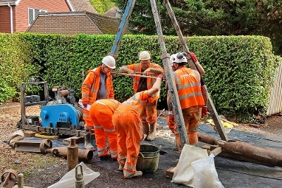
In Upper Basildon, for example, one community relies on a borehole that reaches deep into the chalk to drain excess water.
When it became blocked, flooding followed. But thanks to a coordinated effort between our teams and specialist contractors, the borehole was recently re-cored to a depth of 21 metres - revealing ancient flint and chalk that hadn't seen daylight for 12,000 years. The result? The soakaway cleared, and the flooding subsided.
This is just one example of how we are moving to proactive maintenance. With essential new funding, our team now manages over 17,000 drainage assets through regular maintenance schedules, and dedicated project engineers are assigned to specific areas.
"With essential new funding, our team now manages over 17,000 drainage assets through regular maintenance schedules, and dedicated project engineers are assigned to specific areas."


